Avio Space

Lukla, Kathmandu, & Co: A brief guide to all the airports of Nepal

The tales of the airports in Nepal are quite fascinating. It houses what, often wrongly, is dubbed to be the most dangerous airport in the world. It still houses remnants of an airport so dangerous that when a personnel from the Civil Aviation Authority of Nepal went for a test flight, he “staggered out of the aircraft and vomited noisily”. This aerodrome could easily have bettered Lukla in terms of its dangerousness.

The importance of different airports in Nepal are different. There are STOLports where when operations cease for a week, children can die as medical essentials cannot be accessed. When Hillary Airport, the crucial gateway to Everest shuts down due to bad weather, there’s pandemonium among travelers.

And there’s the sorry, sad tale of the many abandoned airports of Nepal. Let’s take a look briefly at all the airports of nepal.

1.Bajura Airport

Airplane Tower of Bajura Airport.
Photo: Sushil BK|Wikimedia Commons

Bajura Airport is located in the Kolti Municipality of Bajura District in Sudur-Paschim Province. The aerodrome reference code is 1B, and the airport’s reference point is 29°30’13” N latitude and 81°40’06” E longitude. Bajura Airport is situated approximately one day’s walking distance from the district’s headquarters, Martadi.

Image shows the Bajura Airport
Photo: Civil Aviation Authority of Nepal (CAAN)
Year of Start of Operation  01 October, 1984 
Runway Dimension  520 m x 20 m
Operation Hours 1000 LT-1600 LT

1000 LT-1700 LT

2. Chandragadhi Airport

The Douglas Dc-3 , a first aircraft used by Royal Nepal Airlines in Bhadrapur Airport 
Photo:RoundsImaging|Wikimedia Commons

Chandragadhi Airport, located in Bhadrapur, Jhapa District, Province No. 1, is important as it serves as a key hub for travelers headed to Nepal from its eastern border in India. Nepali passengers as well as those from India, Bhutan, and Bangladesh travel to/ from Kathmandu using this airport.

Year of Start of Operation  November, 1963 
Runway Dimension  1500 m x 30 m
Operation Hours 0600LT-1845LT

0630LT-1800LT

3. Bharatpur Airport

DHC-6 Twin Otter parked at the Bharatpur Airport , chitwan
Photo:Ronnie Macdonald|Wikimedia Commons

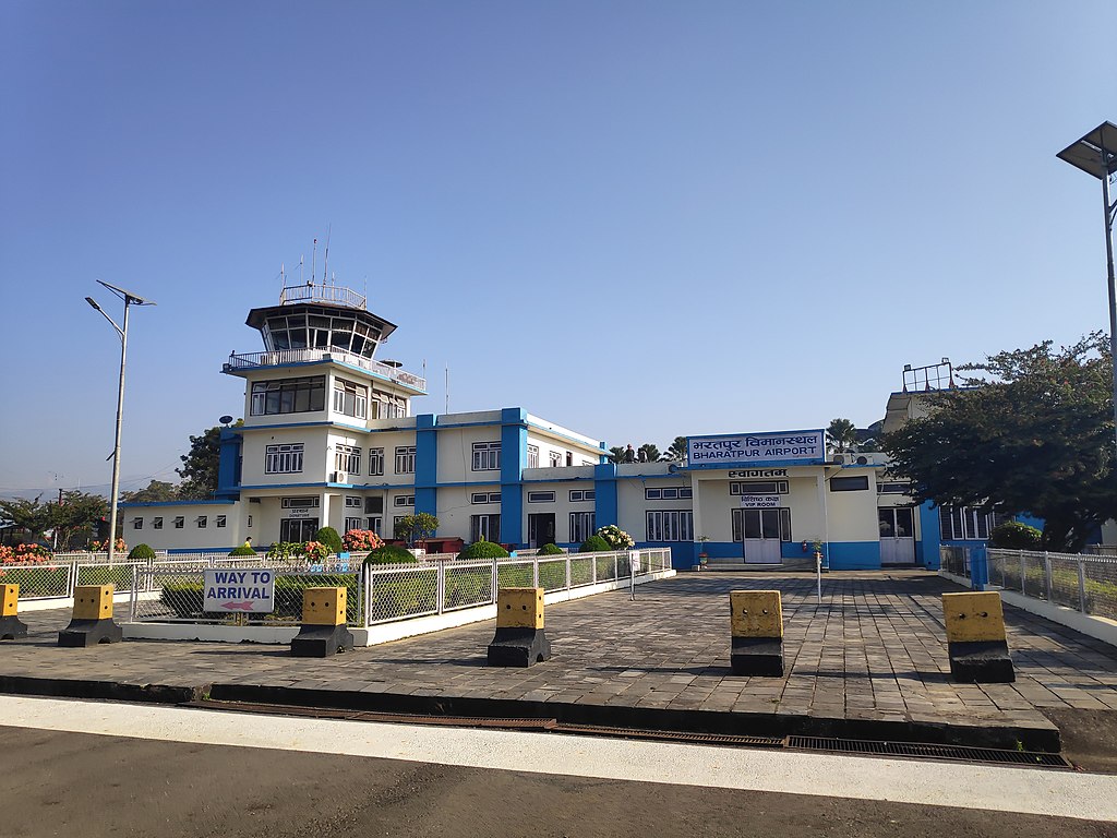
Bharatpur Airport, located in Bharatpur, Chitwan District, Bagmati Province, is a growing domestic hub and gateway to Chitwan National Park. The airport is situated southeast of the city at 207 meters (679 feet), and the airport features a two-person tower, HF SSB, VHF, UHF communication, and NDB navigation. Security includes X-ray, metal detectors, CCTV, and FIDS. It also has reliable power, backup systems, air conditioning, runway lights, and firefighting services.

Gateway of Bharatpur Airport
Photo: Gaurav Dhwaj Khadka|Wikimedia commons
Year of Start of Operation  05 March, 1961
Runway Dimension  1200 m x 30 m 
Operation Hours 0600LT-1845LT

0630LT-1800LT

4. Bhojpur Airport

Inside View of Bhojpur Airport
Photo:Civil Aviation Authority of Nepal (CAAN)
Bhojpur Airport, located in Bhojpur Municipality, Bhojpur District, Province No. 1, is identified by the location indicator VNBJ, IATA code BHP, and an aerodrome reference code of 1B. The airport’s reference point is at 27°08’51” N latitude and 87°03’03” E longitude, situated 5 km south of the city at an elevation of 1208 meters (3962 feet).
Picture of Bhojpur District, Nepal
Photo:Wimbex|Wikimedia Commons
Year of Start of Operation  October, 1978
Runway Dimension  540 m x 20 m
Operation Hours 0600LT-1215LT

0600LT-1215LT

5. Biratnagar airport

Nepalese at Biratnagar Airport in 1963
Photo: Don Christie|Wikimedia Commons
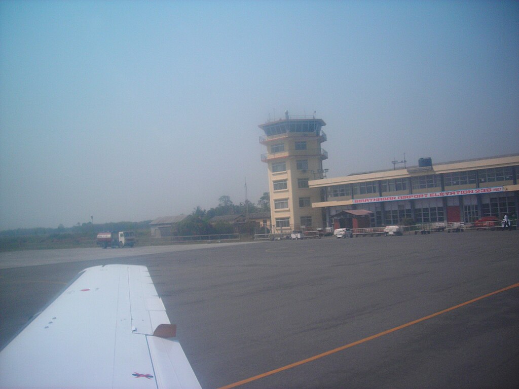
Biratnagar Airport, located north of Biratnagar Bazaar in Morang District, Province No. 1, is a key hub and the first certified aerodrome in Nepal after Tribhuvan International Airport. It is the second busiest domestic airport in the country, playing a crucial role in air travel within Nepal.
Photo taken of Biratnagar airport by unknown people from the inside of aircraft
Photo: Ganesh Paudel|Wikimedia Commons
Year of Start of Operation  6 July, 1958
Runway Dimension  1500 m x 30 m 
Operation Hours 0600LT-1845L

0600LT-1845LT

6. Birendranagar Airport

Surkhet Airport, located in Birendra Nagar, Surkhet District, connects remote western Nepal, including the Karnali zone, Bajura, and occasionally Rukum. It plays a vital role in transporting essential goods like food, medicines, construction materials, and hydroelectric components, making it a crucial lifeline for the region.

Photo: CAAN
Year of Start of Operation  October, 1966
Runway Dimension  255 m x 30 m
Operation Hours 0645LT-1800LT

0615LT-1830LT

0600LT-1845LT

7. Nepalgunj Airport

Passengers Moving towards Tara Airlines Aircraft in Nepalgunj Airport
Photo:Bruno Rijsman|Wikimedia Commons

Nepalgunj Airport, in Banke District, Lumbini Province, is a major hub that has the capacity to connect to 16 airports in Lumbini and Sudur-Paschim Provinces. It provides vital air links to remote areas, including helicopter services, and serves as a gateway for Indian pilgrims to Kailash Mansarovar. With its potential to boost tourism, the airport also features an aircraft maintenance hangar.

The exterior view of Nepalgunj Airport
Photo: Praneet Acharya|Wikimedia Commons
Year of Start of Operation  15 March, 1961
Runway Dimension  1505 m x 30 m
Operation Hours 0600LT-1845LT

0630LT-1800LT

8. Rajbiraj airport

Buddha Airlines aircraft at Rajbiraj Airport
Photo:Suyash Dwivedi |Wikimedia Commons

Rajbiraj Airport, located in Saptari District, Province No. 2, is near Rajbiraj Municipality. It could play a key role in connecting Kathmandu to the Terai regions during emergencies, natural disasters, and calamities.

Terminal 2 view of Rajbiraj Airport
Photo:Aj211|Wikimedia Commons


Year of Start of Operation  20 February, 1960
Runway Dimension  1500 m x 30 m
Operation Hours 1000 LT-1600 LT

0630LT-1800LT 

9. Janakpur Airport

Buddha Air 9N-AMD at the Janakpur airport
Photo:Nirajan_pant|Wikimedia Commons

Janakpur Airport is located in Janakpurdham, Dhanusha District, Province No. 2. This historical and cultural city, known as the birthplace of Goddess Sita, is home to the famous Ram Janaki Temple and Ganga Sagar. Renowned for its Mithila culture and natural beauty, Janakpur Dham, also called the “City of Ponds,” is a must-visit destination for travelers seeking Nepal’s rich heritage.

Janakpur Airport Of Dhanusha District
Photo: Ralf Lotys |Wikimedia Commons
Year of Start of Operation  13 February, 1960
Runway Dimension  1306 m x 30 m
Operation Hours 0600LT-1845LT

0630LT-1800LT

10.Simara Airport

Outside the simara airport
Photo:Barakhabar|Wikimedia commons

Simara Airport, located in Jitpur Simara, Bara District, is a key domestic airport just 39 miles from Kathmandu. Its proximity to Birgunj, a major commercial hub connected to Raxaul (20 km away), and its position along international flight routes, enhance its strategic importance.

11. Phaplu Airport

De Havilland Canada DHC-6-300 Twin Otter at the phaplu airport runway
Photo:Rucksackschule-dresden|Wikimedia Commons

Phaplu Airport is located in the Solu Dudhkundi Municipality of the Solukhumbu District in Province No. 1, near the district headquarters of Salleri. It serves as a gateway to the famous Khumbu Trekking Route, though people prefer trekking after a flight to Lukla.

overview of the runway of Phupla Airport
Photo:Rucksackschule-dresden|Wikimedia Commons
Year of start of operation  October, 1976
Runway Dimension 530 m x 20 m
Operation Hours 0600LT-1215LT0

630LT-1215LT

12.Pokhara International Airport

Scene of the Pokhara international Airport during past time
Photo:Raju Babu|Wikimedia Commons

Located in the Kaski district, Pokhara Airport is Nepal’s third international airport. It officially opened on January 1, 2023, with the expectation that it would simplify life for locals while boosting tourism and the economy. The airport’s runway, classified as ICAO Category 4D, measures 45 meters in width and 2,500 meters in length.

A small picture of outside / exterior look of Pokhara International Airport
Photo:Hariram sigdel |Wikimedia commons


Year of Start of Operation  04 July 1958
Runway Dimension 1447 m x 30 m
Operation hours 


0600LT-1845LT

0630LT-1800LT

13.Dhangadhi Airport

Exterior of Dhangadhi airport
Photo: Gaurav Dhwaj Khadka |Wikimedia commons

Dhangadhi Airport is located in the Dhangadhi Sub-Metropolitan City of Kailali District, in the Sudur-Paschim Province of Nepal. This airport has direct flights to Kathmandu, Doti, Baitadi, Bajhang, and Safebagar.

Year of Start of Operation 26 December, 1964
Land Approx. 301246.94 m2
Runway Dimension 1800 m x 30 m
Operation Hours 1000 LT-1600 LT

1000 LT-1700 LT

14. Argakhachi Airport

As far back as 2017, CAPA had reported that Civil Aviation Authority of Nepal (CAAN) had started the constructionof Argha Bhagwati Airport in Arghakhaachi, with the publication saying that “the project requires an estimated investment of approximately NPR800 million (USD7.7 million) and is expected to be complete within four years.” 

A view of Arghakhaachi, the district where the Argha Bhawati Airport is supposed to be constructed
Photo: Punya | Wikimedia Commons

However, the airport is still under construction. Currently, travelers to Arghakhachi can either take a direct bus from Kathmandu to Arghakhanchi or fly to Pokhara or Bhairahawa and continue by bus. The drive from Pokhara takes about 4 hours, while from Bhairahawa it’s 3 hours. An airport in the district would greatly benefit locals, enhance tourism, and create economic opportunities. Airport on this district is not introduced yet it is still under the construction .

15.Syangboche Airport

Mi-7 Helicopter Takeoff from the syangboche airport
Photo: Chakshu Malla|Wikimedia Commons

Syangboche Airport is located in the Kumjung Municipality of Solukhumbu District, Province No. 1. Serving as the gateway to Mount Everest, it is a STOL airport situated within Sagarmatha National Park. Currently, the airport has no scheduled passenger flights for fixed-wing aircraft. Helicopter operations do take place here, though.

16. Tikapur Airort

Picture of the one of the park of Tikapur
Photo:Hopingyousuf|Wikimedia Commons
Tikapur Airport, one of the many closed, abandoned airports in Nepal, is located in Tikapur Municipality, Kailali District, Province No. 7. The airport is currently.
Year of Start of Operation  11th October, 1984
Runway Dimension  573 m x 30 m
Operation Hours 1000 LT-1600 LT

1000 LT-1700 LT 

 17. Ramechhap Airport

Ramechhap Airport is located in Manthali Municipality, Ramechhap District, Bagmati Province, alongside the Tamakoshi River. It is conveniently near Manthali, the district headquarters. During the tourist season, most flights from this airport connect to Lukla and Phaplu Airport.

Entry way of Ramechhap Airport
Photo:Neilsatyam|Wikimedia Commons
Year of Start of Operation  October, 1979
Runway dimension  530 m x 20 m
Operation Hours 0600LT-1215LT

0630LT-1215LT

18. Jomsom Airport

Runway view Of the (ATC tower)  of Jomsom Airport
Photo: Vyacheslav Argenberg|Wikimedia Commons

Jomsom Airport, located in the Mustang District of Nepal, lies near the Kali Gandaki River and is encircled by stunning mountain ranges, including Dhaulagiri, Annapurna, Nilgiri, and other majestic peaks.


Near View of Jomsom Airport
Photo: Bijay Chaurasia|Wikimedia commons
Year of Start of Operation  March, 1976
Runway Dimension 810 m x 20 m
Operation Hours 0600LT-1215LT

19. Dolpa Airport

Selfie by a person that visited Dolpa airport
photo:Bijayautsav|Wikimediacommons

Dolpa (Juphal) Airport is situated in Juphal Municipality, Dolpa District, in Karnali Province. It serves as the entry point to Shey-Phoksundo National Park, home to the beautiful Phoksundo Lake, a major attraction. The airport also provides access to the Upper Dolpa Trek, a popular destination for tourists.

Year of Start of Operation  1975
Runway Dimension 560 m x 20 m
Operation Hours 0600LT-1215LT

0630LT-1215LT

20. Gorkha Airport

Dornier Do-228 at the Gorkha Airport
Photo: Paul Spijkers|Wikimedia Commons

Gorkha Airport is located in Palungtar Municipality, Gorkha District, Gandaki Province. Despite having been built before the Lukla Airport, the airport is not in operation.

21. Manamaya Rai Khanidanda Airport


Manamaya Rai Khanidanda Airport is situated at Khotang Municipality of Khotang District, Koshi
Province
Photo: Civil Aviation Authority of Nepal (CAAN)

Man Maya Airport, also called Khanidanda Airport, is a domestic airport in Rupakot Majhuwagadhi that serves Khotang District, a district in Koshi Province, Nepal.

Year of Start of Operation  2062 B.S. 
Runway Dimension  580 m x 25 m
Operation Hours 0600LT-1215LT

0630LT-1215LT 

22. Falgunanda Airport

Falgunanda Airport one of the domestic Airport of eastern Nepal
Photo: Civil Aviation Authority of Nepal (CAAN)

Falgunanda airport is located in Sukilumba, Ilam District, Province No. 1 in eastern Nepal. The test flight was conducted on Jestha 21st, 2075. This airport is getting upgraded to Asphalt Concrete. Only half a year ago, news of flight operations by Nepal Airlines from Falgunanda Airport surfaced.

23. Tenzing Hillary (Lukla) Airport

Runway of Lukla Airport
Photo:Nirojsedhai|Wikimedia Commons

Khumbu Pasang Lamhu-2 Rural Municipality in Solukhumbu District, Province No. 1, is home to Tenzing-Hillary (Lukla) Airport, the gateway to Mount Everest. Located within the Sagarmatha National Park buffer zone, it is a crucial STOL airport, key for foreign currency earnings and the busiest of its kind.

Royal Nepal Airlines 9N-ABT parked at Lukla Airport
Photo:Calistemon|Wikimedia Commons
Year of Start of Operation  September, 1971
Runway Dimension  527 m x 20 m
Operation Hours 0600LT-1845LT

0630LT-1800LT

24. Rara Airport

snowy covered runway of the Rara Airport
Photo:Tannu 01|Wikimedia Commons

Rara Airport, located in Karkibada Municipality of Mugu District, Province No. 6, serves as a key gateway to Rara Lake and Rara National Park. It’s about a 2.5-hour walk from the lake and lies near the park’s boundary, within its Buffer Zone.

Year of Start of Operation  19 October, 2003
Runway Dimension  570 m x 20 m
Operation Hours 0645LT-1230LT

0615LT-1230LT

0600LT-1230LT 

25. Rukum Salle Airport

Rukum Salle Airport
Photo: Rambsham | Wikimedia Commons
General Information of the Rukum-Salle Airport.
Photo: CAAN

Rukum Salle Airport is located in Khalanga Municipality, Rukum District, within Province No. 5. It is connected by air to Nepalgunj and Kathmandu.

26. Sanfebagar Airport

General Information about Sanfebagar Airport as given out by CAAN.
Photo: CAAN

The Sangebagar Municipality in Achham District, Sudur-Paschim Province, is home to Sanfebagar Airport. Mangalsen, the district headquarters, is close by.

27.Bajhang Airport

Bajhang Airport, located in Rithapata Municipality, Bajhang District, Sudur-Paschim Province, has the IATA code BJH and the location indicator VNBG. It sits at an elevation of 1224 meters and covers 66,380.07 m². The airport operates from 1000 LT to 1600 LT (Nov-Jan) and 1000 LT to 1700 LT (Feb-Oct), but it is currently not in operation.

General Information of Bajhang Airport.
Photo: CAAN

It started in October 1976 and serves VFR traffic with no refueling facility. The runway is 630 meters long and 20 meters wide, and it can accommodate two DHC6 aircraft. No scheduled flights or RFF services are available.

28. Baitadi Airport

Runway of Baitadi Airport 
Photo: : Civil Aviation Authority of Nepal (CAAN)

Baitadi Airport, located in Patan Municipality of Baitadi District, Sudur-Paschim Province, has been inactive since its operation began on February 27, 1978, with an elevation of 1258 m and a land area of 89,156.26 m².

29. Doti Airport

Image of Doti Airport located in Dipayal Silgadhi
Photo: Civil Aviation Authority of Nepal (CAAN)

Doti Airport is located in Dipayal Municipality, Doti District, Province No. 7. The airport is currently not in operation. It has the location indicator VNDT and the Aerodrome Reference Code 1’A’ Type 2. The reference point is at 29°15’47” N / 080°56’10” E, with an elevation of 577 meters (1893 feet).

30. Gulmi (Resunga) Airport

Picture of Gulmi Airport
Photo: Civil Aviation Authority of Nepal (CAAN)

Gulmi (Resunga) Airport is situated in Simichaur, Gulmi District, Lumbini Province. A test flight was conducted on Jestha 25th, 2075. The airport’s reference point is at 28°01’17.58″ N / 083°15’20.40″ E, with the location indicator VNRG. It is located 5 km south of the Palpa Tamghas Road and sits at an elevation of 1529.267 meters (5015 feet).

31.Baglung Airport

Baglung (Balewa) Airport, located 6 km east of Baglung city at an elevation of 990 meters, is not in operation. It covers 78,793.27 m² and has a 608m clay/grass runway.

General Information of Baglung Airport, as provided by CAAN
Photo: CAAN

The airport serves VFR traffic with aircraft like DHC6, Y12, and C208 but lacks refueling and passenger facilities. It operates seasonally, with hours from 1000 LT to 1600 LT (Nov-Jan) and 1000 LT to 1700 LT (Feb-Oct).

32. Langtang Airport

Langtang Airport is situated at Langtang Municipality of Rasuwa District, Bagmati Province. This airport lies in the area of Langtang National Park. The airport is not in operation.

General Information of Langtang Airport provided by CAAN.
Photo: CAAN

33. Kangeldenda Airport

Nepal Airlines 9N-ABU at the Kangeldanda Airport
Photo:Civil Aviation Authority of Nepal (CAAN)

Kangeldanda Airport, located in Solukhumbu District, Province No. 1, is a key connection hub for the region, benefiting over 50% of the population. The district has four STOL airports, and a test flight was conducted on 30th Mangsir 2077. It is one of the four airports in Solukhumbu district.

34.  Rumjatar Airport

Control tower of Rumjatar Airport
Photo: Civil Aviation Authority of Nepal (CAAN)

Rumjatar Airport (IATA: RUM, VNRT) is located in Siddhi Charan Municipality, Okhaldhunga District, 12 km southeast of Okhaldhunga Bazaar. At an elevation of 1,371 meters (4,498 feet), it has an aerodrome reference code of 1B, with coordinates 27°18’13” N and 86°33’02” E.

35. Darchula Airport

Aerial View of Darchula Airport
Photo: Civil Aviation Authority of Nepal (CAAN)
Darchula Airport (IATA: DAP, VNDL), located in Gokuleswor Municipality, Darchula District, Sudur-Paschim Province, opened on January 26, 1986, but is currently not in operation. It sits at 676 meters (2,218 feet) elevation with a 590 m x 30 m earthen runway (07/25) for DHC6 aircraft. This airport which is not in operation could be has VFR capabilities and also has AFIS services but lacks refueling and RFF facilities. It covers an area of 45,786.60 m² and is open seasonally.

36. Dhorpatan Airport

view of the Dhorpatan airport
Photo: Civil Aviation Authority of Nepal (CAAN)

Dhorpatan Airport (VNDR) is located in Bobang Municipality, Baglung District, Gandaki Province, within the Dhorpatan Hunting Reserve. Opened on September 24, 1973, it is not in operation. The airport has an elevation of 2,728 meters (8,950 feet) and an aerodrome reference code of 1B, with coordinates 28°31’00” N, 83°02’00” E. It covers 109,460.49 m², provides AFIS services, but lacks refueling facilities and operates under VFR.

37. Lamidanda Airport

Runway of Lamidanda Airport
Photo: Civil Aviation Authority of Nepal (CAAN)

Lamidanda Airport is located in the Rawabesi Rural Municipality of Khotang District, Koshi Province. The airport currently only offers air transportation to and from Kathmandu. In addition to Lamidanda, Khotang District is home to two other airports. This airport is conveniently located near the renowned pilgrimage site, Halesi Mahadev.

 38. Kamal Bazaar Airport

Kamal bazar, established on September 18, 2015, in Achham District, Sudurpashchim Province, was formed from several village development committees. A key trade center in East Achham, it offers essential services like a health center, banking, and is powered by wind and solar energy. The administrative hub is in the former Bayala area. Kamal bazar continues to grow, improving services and infrastructure for its residents

39. Kalikot Airport

some details about Kalikot Airport
Photo: Civil Aviation Authority of Nepal (CAAN)

Kalikot Airport is located in the Narharinath Rural Municipality of Kalikot District, in the Karnali Province. A test flight was successfully conducted on February 11, 2017.

40. Meghauli Airport

Over view of Meghauli Airport
Photo:Civil Aviation Authority of Nepal (CAAN)

Meghauli Airport (IATA: MEY, VNMG) is located 24 km south of Bharatpur, Chitwan, near Chitwan National Park. Established in 1966, it is not currently in operation. The airport has an elevation of 152 meters (499 feet), an earthen runway (1,067 m x 30 m), and can accommodate two DHC6 aircraft. It operates under VFR with AFIS services but lacks refueling and RFF facilities. The airport covers 141,006.15 m² and has a 3,500 m² apron. Seasonal operating hours are 10:00 LT to 16:00 LT (Nov 1–Jan 30) and 10:00 LT to 17:00 LT (Feb 1–Oct 30

41.Rolpa Airport

piece of information about Rolpa airport
Photo:Civil Aviation Authority of Nepal (CAAN)

Rolpa Airport (IATA: RPA, VNRP) is in Bodachaur, Rolpa District, Province No. 5. It opened on November 6, 1980, but is not in use today. The airport sits at 1,250 meters (4,100 feet) above sea level, has a small earthen runway (457 m x 30 m), and provides basic air traffic services, but doesn’t have refueling or emergency facilities.

42.Jiri Airport

This was the place where airport construction was planned
Photo:Arun Aryal|Wikimedia Commons

Jiri Airport (IATA: JIR, VNJI) is located in Linkon Municipality, Dolakha District, Bagmati Province, near Jiri Bazaar. Opened in October 1976, it is currently not in operation. The airport sits at an elevation of 1,848 meters (6,063 feet), has an aerodrome reference code of 1B, and provides AFIS services, but lacks refueling and RFF facilities. It is one of the many airports in Nepal which is not in operation.

43. Thamkharka Airport

The Badka Diyale Municipality in Khotang District, Province No. 1, is where Thamkharka Airport is located. Biratnagar and Kathmandu are connected by air to the airport. Thamkharka Airport is one of three airports in the Khotang District

44. Mahendranagar Airport

ImageofMahendranagar Airport
Photo: Civil Aviation Authority of Nepal (CAAN)

Mahendranagar Airport is located in Mahendranagar Municipality, Kanchanpur District, Sudur-Paschim Province. Positioned near the Sukla Phanta Wildlife Reserve, the airport is also in close proximity to Mahendranagar Bazaar and serves as a gateway to Naini Taal, a popular tourist destination in India. However, the airport is currently not in operation. This airport remains in the list of abundant airports of the country.

45. Khiji Chandeshwori Airport

Aircraft In KHIJI CHANDESHWORI AIRPORT
Photo: Civil Aviation Authority of Nepal (CAAN)

Khiji Chandeshwori Airport is situated in Okhaldhunga District, Province No. 1, in eastern Nepal, close to the populated Khiji Phalante area. A test flight was conducted on Paush 7th, 2076. Currently, the airport’s naming, the publication of aerodrome data, and the issuance of the ICAO Location Indicator are still in progress.

46.  Gautam Buddha international airport

Gautam Buddha International Airport (BWA), in Siddharthanagar, Nepal, serves Lumbini and the Butwal-Siddharthanagar area. It became Nepal’s second international airport in May 2022.
Photo:Santoshgurung1982|Wikimedia Commons 

Gautam Buddha International Airport serves as a key international gateway located in Siddhartha Nagar Municipality, Rupandehi District, Lumbini Province. It is Nepal’s second international airport, coming after Tribhuvan International Airport in Kathmandu.

47.TAPLEJUNG AIRPORT

Image of Gautam Buddha International Airport
Photo: Civil Aviation Authority of Nepal (CAAN)

Taplejung Airport is located in Phungling Municipality, Suketar, within Taplejung District, Province No. 1. Serving as a key gateway to the Kanchanjanga Conservation Area and the renowned Pathivara Temple, it is an important hub for tourism. The airport is connected by air to Chandragadhi and Kathmandu.

48. Tumlingtar Airport

Tumlingtar Airport is located in Khandabari Municipality-9, Sankhuwasabha District, Province No. 1. Serving as the gateway to Makalu-Barun National Park, renowned for its natural beauty and biodiversity, the airport plays a crucial role in promoting trade and tourism. Furthermore, it significantly contributes to the socio-economic development of the entire region.

49. Tribhuwan International Airport

Close View of Tribhuvan International Airport
photo: Chainwit|Wikimedia commons

Tribhuvan International Airport, located in Kathmandu, the capital of Nepal in Province No. 3, serves as the country’s main international gateway. It is the busiest airport in Nepal regarding passenger traffic and is the sole entry point for international flights, while also connecting to all domestic airports.

50.Nijgadh International Airport

Aerial View Of Nijgadh International Airport
Photo: Nijgadh|Wikimedia Commons

Nijgadh International Airport, located in Kolhabi, Nepal, is set to be South Asia’s largest and the fourth largest globally by land area. With a $6.7 billion investment, it aims to ease capacity issues at Kathmandu’s Tribhuvan International Airport, with completion targeted for 2025.

51. Manang Airport

Beautiful view of the Manang Airport
Photo: Sergey Ashmarin|Wikimedia Commons

Manang Airport, situated in Gandaki Province at an altitude of 11,093 ft, is Nepal’s highest airport. It is a vital gateway for trekkers exploring the Annapurna Circuit and Tilicho Lake, offering quick access to these renowned destinations.


Scroll to Top